BETTER MAPS FOR THE 21st CENTURY BATTLEFIELD:
"I'm a mean man with a map!"
Reggie Vanderock, Fred Flinstone's WWI flying ace ancestor
 www.youtube.com/watch?v=x-RSGKxQLmY
While humorous, there is an element of truth in what he says. With a good map, we can see ahead to where we are going and make intelligent decisions. For this to work maps must be easy to understand.
The military topographical maps that we use are not easy to understand. If they were, they would be self-explanatory. The following changes can help make maps produced by The National Imagery and Mapping Agency (NIMA) understandable to the Private just entering the Army. If Privates are not being taught these things, then we are spending too much time on non-sense in recruit training.
GEO-COORDINATES
At the bottom of each NIMA map should be an explanation of GEO-COORDINATES and how this map fits in. U.S. Army Field Manual 21-26 Land Navigation is a great place to start, as is the NIMA link previously provided under "GEO-COORDINATES": http://164.214.2.59/GandG/geolay/toc.htm. Chapter 4 specifically describes grids. There are longitude and latitude lines that have been set by map makers to navigate over the earth. Airplanes and ships take long/lat and navigate with them using subdivisions of degrees, minutes and seconds. Ground troops do not move across the earth as fast and need to move with greater appreciation of the terrain. If an airplane pilot makes a mistake, and flies 10 miles off course, it can be corrected in a matter of seconds, a Soldier would have to march all day to get where he is going.
In the U.S. military, we use the Military Grid Reference System (MGRS) that is based on the Universal Transverse Mercator (UTM) and Universal Polar System (UPS). What this means is that the round earth has been sliced into a rectangle to make a map. Universal meaning the world, transverse means going across, and Mercator is the name of the inventor of this map. The problem is the world is somewhat round! A Mercator projection is not accurate at the North/South Poles. For them, we use a cone shaped projection and the UPS. Most Soldiers will operate in the UTM.
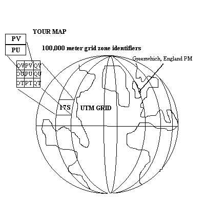
To organize maps of the earth, we have taken every six degrees of longitude and 8 degrees of lattitude and called it a number from 1 through 60, since 6 degrees times 60 equals 360 degrees, or a complete circle. The center line at the equator is where lines of latitude cut across to create UTM grid zones. The letters A/B and Y/Z are reserved for UPS, so where ever you are in the world, you are in either UPS or UTM that can be plotted within a grid zone number and letter. Each grid zone letter and number are subdivided by 100,000 meter grid square identifiers with two letters (AA, AB, AC, AD etc....).
This is all done so the Soldier can radio his exact position without having to use long/lat. The Soldier can now use a grid system of numbers 1 through 9 in meters as long as he specifies what UTM grid he is in and what 100,000 meter grid square identifier he is in. NIMA maps come with MGRS grid lines. When radioing in your position you read right then up. A four digit grid coordinate is read like this: "12" "34". This means I am 1200 meters right and 3400 meters up inside a 100,000 meter grid square. You can take a protractor and measure within the grid square and get a 6, 8 or with Global Positioning System (GPS) AN/PSN-11 receiver or "plugger" a 10 digit grid coordinate accurate to 100, 10 and 1 meters.
Six digit grid coordinate: "123" "456"
Eight digit grid coordinate: "1245" "6789"
10 digit grid coordinate: "12345" 67890"
NOTE: that as you measure your RIGHT and your UP grid coordinates, leave a gap between them so you do not get your numbers confused. Or you can place a slash between the two sets of numbers. I also suggest putting a decimal point after the initial set of 4 digits grid coordinates to remind you that the following numbers are smaller decimal places. Begin with a 4 digit grid coordinate "22 34":
"22" / "34" At this point everything you do refers to the immediate RIGHT and UP grid square where these two points meet.
Then as you eyeball or map protractor measure the point inside the right/up grid square you are in, write in the next set of numbers.
"22.3" / "34.5"
"22.34" / "34.57"
"22.345" / "34.570"
The final Gird coordinate: 17S PV 22.345 / 34.570
This means you are in UTM grid zone 17S, in 100,000 meter square identifier PV, 22,345 meters RIGHT and 34,570 meters UP.
It's all really a giant game of Battleship, if you remember from your childhood. But you can be at different parts of the globe and have the same grid coordinate numbers. This is why it is important that you state your grid coordinate with the UTM grid zone you're in and the 100,000 meter grid square identifier you are in before giving the numbers. The NIMA maps at the bottom tell you what UTM grid zone you are in and the 100,000 meter grid square identifiers on the map.
An example correct geo-coordinate: 17S PV 12345 / 12345
This means that you are in the 17th UTM grid square west of the prime meridan (Greenwich, England) in UTM zone S. PV is one of the 100,000 meter grid square identifiers that run across Fort Bragg, North Carolina. Traveling west to Fort Benning, you can anticipate being in a different UTM grid zone, which it is. It's in 16S. This means that you have crossed 6 degrees of longitude to get to Fort Benning, but have not gone far enough south to get into a different UTM grid zone with different north-south code letter. Look at the UTM Grid Zone 15S and 16S close up depicted above. Look at the lower right corner of UTM Grid zone 16S, see 100,000 meter grid squares FL and GL slightly shaded in for instructional purposes? This is the area where Fort Benning, Georgia is located. You could be in either 100,000 meter square while operatin on post, so you must prefix your grid coordinates with "FL" or "GL" accordingly.
TO ILLUSTRATE WHAT UTM YOU ARE IN, EVERY NIMA MAP SHOULD HAVE A SCHEMATIC DRAWING OF THE EARTH SO THE SOLDIER CAN SEE WHERE THE MAP FITS IN. (See the sample schematic above). The grid zone the map is in should also be displayed prominently at the top of the map: "17S" "16S" etc. See the "better map" drawing below.
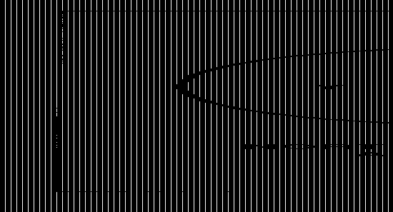
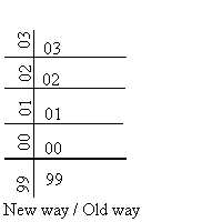
The problem is, maps usually have parts of two 100,000 meter grid square identifiers on them. You will notice that the grid zone numbers will stop at 99 and start at 00 again. This is the first thing we need to improve upon.
WHEN 100,000 METER GRID SQUARE LINES STOP AND/START THE GRID LINES SHOULD BE THICKER SO THE SOLDIER CAN REALIZE HE IS LOOKING AT A DIFFERENT GRID SQUARE AREA. See drawing of a better map above.
MAP CLUTTER
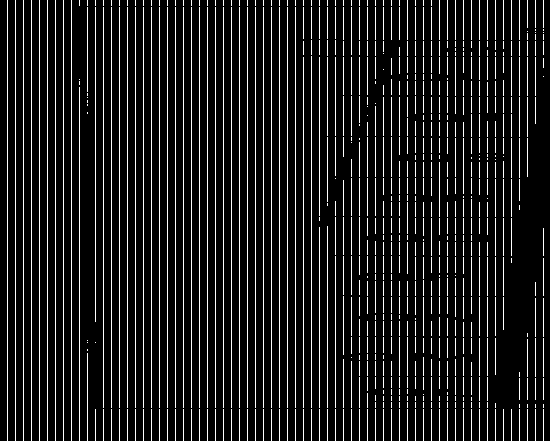
To help the Soldier, NIMA runs grid numbers across the map for both right and up. The problem is both numbers are horizontal. If you are cold, wet and tired, you can easily confuse a west to east (right grid coordinate number) with an south to north (up number). The simple solution is to make UP numbers sideways on the map, so that Soldiers know that they are UP numbers. See "better way to show UP numbers" drawing below.
Grid numbers should be in red or some other color, than black, to stand them apart and not clutter details. One thing you can do now is to get a yellow highlight pen and mark you grid numbers so that they stand out. But after you do this, be sure to laminate your map, because highlight pen will run if it gets wet.
BETTER MAP READING TRAINING...
A former Army officer writes:
"Because of my ability to read maps I ended up teaching map reading and navigation to people who had problems. My own abilities had nothing to do with intelligence. They were a gift; something I did instinctively without working at it. My brother has severe right-brain/left-brain imbalances which leave him unable to do things like read maps or anything having to do with spatial problems. He is fine with the concepts but unable to do these kinds of things in real life. My father who is pretty bright taught him things spatial by taking it out of the spatial context. I used this method to teach map reading.
One of the aids I used was a piece of Plexiglas (appropriated from the AF) cut five inches by six inches and duct taped around the edges. I drilled a hole in one corner and put parachute cord through it to make a lanyard. In the lower left hand corner I scratched in the word right and next to it I drew an arrow pointing to the right. I then scratched in a vertical line. In the middle of the plastic I scratched the word UP and put and arrow above it pointing up. I them drew a horizontal line above that extending to the end of the end of the plastic. After I had this crude tool I got a piece of paneling ( thank God for the AF) four by eight and cut it in half. I painted the back side of both pieces white. On one I drew black vertical line about four inches apart and on the other I drew horizontal lines four inches apart.
I would then make my student stand up and face the board with the vertical lines with his little piece of plastic in his left hand. I would make him side step to his right and call out right on every step. After doing this for a minute or so I would have them stop and write two digit numbers to the right of the vertical lines ( 11, 22, 33, etc.).
Next we would get in front of the board with horizontal lines. Still holding there little piece of plastic in there left hand I would make them squat down and start calling out UP, and jump up at the same time (the officer's in particular got quite irritated sometimes). After doing this for a minute or so we would switch to jumping up and writing numbers above the lines. I was trying to take advantage of things they had already been taught. Now they call it muscle memory. Every Soldier knows his right ('YOUR MILITARY RIGHT') and which way is up ('WHAT ARE YOU LOOKING AT DOWN THERE, GET YOUR HEAD UP TROOP'). It was something which you have pushed on you from the start in basic. I was just trying to take advantage of that.
Next I would go to the map. Instead of leaving it flat on a table I would tape it to the wall and make the student stand up in front of it. I would then call out the first two digits of the coordinates and make the student step to the right and find them. Then I would have them take there little piece of plastic and align the vertical line on the top of the vertical map line and over the grid number. In grease pencil they would then put the numbers next to the word right scratched on the little piece of plastic. The same process would be repeated for the up portion. It worked. I probably had a ninety percent success rate for students who already were having trouble reading maps. With two students in particular I failed, so I know this won't work for everybody.
All you are trying to do is take advantage of things the students already do pretty well, like knowing there right from there left and looking up. I believe that a lot of the people who have trouble with maps have spatial problems like my brother. You have to take advantage of muscle memory they already have. That's why had them put the map on a wall instead of laying it down flat on the ground. For someone with spatial problems The Neural pathways don't function very well so you have to take advantage of what they can do. They have learned to go to there right and look up from a standing position. As soon as they try to assimilate data (like a map) and perform visualizations flat on the ground they're in trouble. you can test this very easily by observing someone who can't seem to get it. Lay the map flat and see if they become agitated and fidgety. then put the map on the wall. They will still be confused but not anxious. My two failures were left handed. I taught other lefties to do this so I'm not sure it has anything to do with it but it's something to remember. I also had a disproportionate number of lefties as students. The most important thing I had them do was to write there coordinates like this. RIGHT 12- 34 AND UP 56-78. I would then have them combine the numbers. One other thing. I always taught these students individually. It only took about thirty minutes and usually I only had to do it once.
P.S. While watching our troops move into Bosnia years back I noticed a Col. briefing some officers. He was holding the map up against a Bradley with his right hand and he was holding a five by six inch object in his left hand. It clearly had a lanyard on it around his neck. Maybe it was something else but I like to believe it was a young lieutenant I taught to read a map years ago."
ORIENTING YOUR MAP
Many Soldiers in the field get disoriented and confused when trying to look at the map and figure out where they are in reality viewing their surroundings. The first bedrock reality that is non-changing is that the top of NIMA maps is GRID north, the bottom is grid south, the right side is grid east, the left side is grid west. Each NIMA map should have N, S, E, W on the approiate ends of the map so Soldiers always know that the map must be oriented to be read right. See illustration "B" above for details.
DETERMINING GRID COORDINATES AND AZIMUTHS
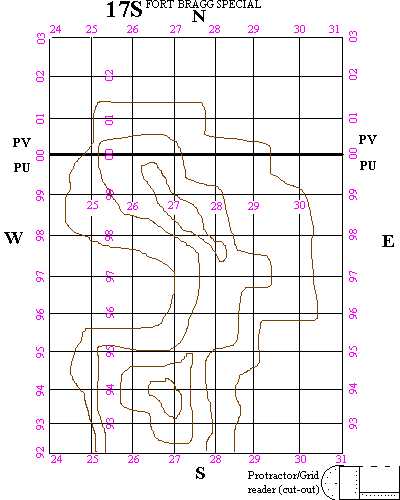
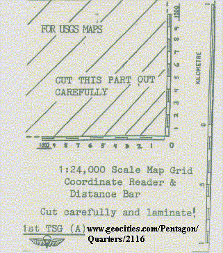
As said before, once you get into a 4-digit grid coordinate (box) you are in a 1,000 meter by 1,000 meter grid, if its a 1:50,000 scale map. To get a closer measurement where you are, you take a clear protractor and measure distances inside by 100ths, 10s and 1s to get 6, 8 and 10 digit coordinates. What if you do not have a protractor? What do you do if no protractor exists for the only map you have of the area because its in an odd scale, like U.S. Geological Survey Maps (USGS) in 1:62,000 or 1:24,000 scale? Your GPS plugger can give you a 10-digit grid coordinate but you cannot plot it accurately on your map. If you do not have a plugger, you cannot do either. In a previous AES article, we described how a grid reader could be made by xeroxing the bar scale on the bottom of the map to create one.
Below is a 1:24,000 scale map grid reader and distance bar we created that can be reproduced on your personal computer printer. You can then take it to a photocopy machine and mass produce for your Soldiers to laminate and use in conjunction with USGS 1:24,000 scale maps.
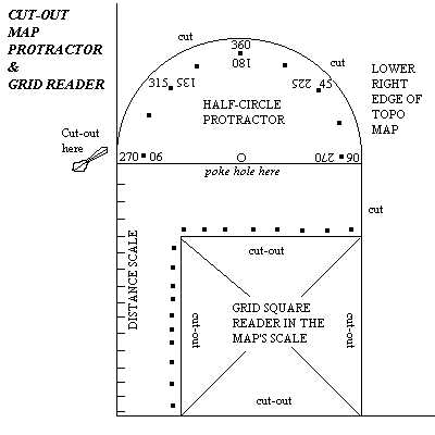
What should happen is that a protractor/grid reader should be printed on the lower right corner of every NIMA map so a Soldier in dire need could cut it out and use it to plot points and measure azimuths. If he has a small piece of clear lamination plastic, he can even cover this for a durable protractor/grid reader that will last mulitple uses. While it is true the G.I. Lensatic compass can be used to draw azimuths lines on a map, the map must be oriented precisely to GRID north (map must be offset to reflect the G-M angle since a compass needle points to magnetic north in Canada, not the north pole) and this is difficult to hold still out in the field where there is no flat surface to lay the map down on. There is no reason why a simple protractor/grid reader couldn't be printed on the lower corner of the map for Soldiers to use in emergencies. A prototype drawing not to scale is illustrated, refer to the drawing below. Please scroll up to the better map drawing above and notice where the protractor would be on the map for easy cut-out, maximizing the straight edges that come already on the map.
To use a protractor that is not see though you need to draw extended lines on your map Azimuths in order to get a reading. If you agree to these types of changes, please contact NIMA and voice your support for them. Only if there is a lot of Soldiers requesting this will they see the need. Their address and email address are listed below.
NIMA General Help Desk (L-52)
3200 South Second Street
St. Louis, Mo. 63118-3399
DSN: 490-1236
Toll free: 1-800-455-0899
Commercial: (314) 260-1236
Fax: (314) 260-1128
DSN Fax: 490-1128
e-mail: chdesk@nima.mil
web site: http://www.nima.mil
After submitting this to NIMA, I get an email asking for my name, rank and unit...
This isn't about me. Its about US--all of us who use NIMA and USGS maps. I also teach Land Navigation frequently to Soldiers and their confusion (I can hear it now--"If you were a better teacher") drives me to propose these changes. What most people in the service do not understand is that there is a LIMIT TO THE AMOUNT OF INFORMATION A SOLDIER CAN KEEP IN HIS HEAD AT ONE TIME. Imagine if you had dozens of windows operating on your computer, and have most of its memory taken up. How would your computer work then at looking at web pages? Examples: the people making Army binoculars want you to remember each number is 10 mils, not 1s as they are labeled (whatever happened to saying what you mean?). Your maps ask us to remember "right then up", the G-M angle, LARS, to keep your map oriented when making observations of it and the terrain around you, and a host of others. Each other field of Soldier tasks asks you to remember things that if viewed by themselves look easy and reasonable. The truth is TOGETHER all these things increase complexity and increase the chances for a mistakes. Mistakes can get you and your men killed---walking into a minefield etc. you get the picture. KISS principle: Keep It Simple, Stupid.
I expect this "piecemeal" status quo defense from those at NIMA on each suggestion. They will say; "why should WE change?" "What we have is simple and is easy to understand" etc etc. "Soldiers need to be trained better". This is the solution for all problems, and if something goes wrong---the other side of this mentality is set: the Soldier is to blame for everything that goes wrong. If something goes wrong, it is the individual Soldier who gets hammered, that way SYSTEMIC PROBLEMS--like Soldier's mental overloading created by an institution that looks at issues with narrow-minded legalism instead of holistic reality, go ignored. Yes, if you are in an air conditioned office, fully rested without a 80 pound rucksack on your back or full of fear that this may be your last day alive on earth (combat), you may conclude--wrongly----that NIMA maps are "all that they can be". They are not. They need to be.
Today's world moves by the speed of AIR and is linked together by instant space-based observation means. It is entirely likely that a unit in deepest, darkest Africa could be sending a message by TACSAT all the way back to the CONtinental United States (CONUS). For them to know exactly where you are, you are going to have to tell them. You have to tell them exactly what UTM grid zone you're in, what 100,000 meter grid square identifier you are in before you send over a numeric 4, 6, 8, or 10 digit grid coordinate. From this information a flight of C-17 Globemaster III full of paratroopers, M113A3 Gavins, other light AFVs, human powered vehicles, ammunition, MREs and supplies could be there in a matter of hours. Or it could be a F117A Stealth Fighter dropping a laser guided bomb that flies to your GPS coordinates signaled in instead of you shining a laser beam at the target. On top of all of this, you have to add the datum that your map sheet is based on so the bombs fall, the supplies land and the Paratroopers link up where you want them to----and not on your head. You cannot expect a pilot flying seconds away from diving into the ground to double-check your map work. All NIMA maps are not based on the WGS84 datum necessary to be GPS compatible. Others like NAD27 and from other countries are based on an arbitrary point on the earth's surface and thus you could state the exact geo-coordinate of where you are at for that datum, but if you neglect to tell the jet flying above you who is using WGS84 he will bomb a DIFFERENT piece of ground than what you want but LABELED WITH THE SAME geo-coordinate!
"The Global Positioning System also provides unique capabilities to the services not envisioned when the first GPS satellites were launched 20 years ago. GPS was originally designed to provide 24-hour navigation services, which it does well, but is now also used to deliver precision-guided munitions.""This new generation of smart weapons will save lives,"
--Maj. Gen. Gerald F. Perryman Jr., who commands AFSPC's warfighting arm -- 14th Air Force adds:
"Our pilots are no longer tied to their target ... they can 'fire and forget' thanks to the accuracy provided by GPS targeting and guidance systems. New, precision-guided munitions allow one pilot on a single pass to take out several targets. This makes space technology a real force multiplier -- it allows us to send fewer people to do the same job."
Perryman pointed out the 24-satellite GPS constellation is also a neutralizer of traditionally bothersome environmental factors.
"The Navy's Tomahawk cruise missile can fly day or night, in rain and fog, or through heavy battlefield smoke due in a large part to GPS...Although space is critical to winning any battle today, many times that fact is forgotten"
FEEDBACK!